Coordinate Systems
A coordinate system is a mathematical framework used to specify the position of objects in space, consisting of an origin, axes, and axis orientation (x, y и z).
A frame is a named coordinate system tied to a specific object or area. Its position can be expressed relative to another frame.
Note
To manage frames on Klever quadcopters, we utilize the ROS package tf2.
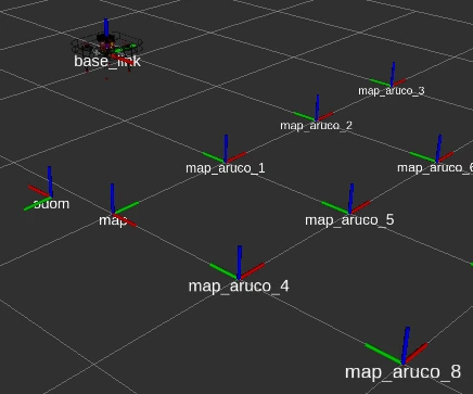
Example of frame arrangement in space
The primary frames in the clover2 package follow the REP 105 convention:
base_link— Coordinate system attached to the quadcopter bodyodom— Coordinate system relative to the flight controller’s initialization pointmap– Coordinate system relative to the marker map (this name can be customized in the configuration, though we recommend using the standard name for compatibility)
In this hierarchy, base_link moves and rotates alongside the quadcopter, while odom and map serve as fixed reference systems to determine the vehicle’s position in space.
Additionally, a unique frame is generated for every marker in the map. By default, these are named map_aruco_<id>, where <id> represents the specific marker identifier.
Hint
The origin of a frame is located at the intersection of the colored axes. The arrows indicate the positive direction of each axis: X (red), Y (green), Z (blue).
In accordance with REP 103, the quadcopter’s body frame is oriented as follows: the X-axis points forward, the Y-axis points left, and the Z-axis points up.